Thailand Travel Trip: Thailand Travel Informations and Map Guide.

Thailand Travel Trip is a Thailand Travel Informations Guide Photos and Map represent to travellers or everyone who interesting the nice places based in Thailand included major provinces, cities Bangkok, Pataya ChiangMai, Phuket & etc. Have you interesting Thai Temples, Wat Pra Kraw, Beaches, Pataya Beach, Patong Beach, Islands, Samui Island, Samet Island, Koe Change, Koe PP, Huahin, Cha-am, Waterfalls, National Parks, Forest, Kaoyai National Park and more...

Thursday, July 26, 2007

The World Longest Gravity Dam in Thailand

The world longest gravity dam in Thailand Khundarn Dam or Khundarn Prakarn Chon.

My trip to Khundarn Dam (เขื่อนขุนด่าน) or the full name Khundarn Prakarn Chon(เขื่อนขุนด่านปราการชล). Khundarn Dam is a world longest gravity dam located at "Ban Tah Darn" Hin Tang destrict NakornNayok province Thailand. A dam is constructed totally 2,720 meters length 93 meters height and maximum water dam up capacity 224 million cubic meter.


Evening time at back of the dam look at the sun is falling.

My trip is started by drive a car from the Future Park Rangsit used the highway no. 305 Rangsit-Nakhonnayok Pathumthani province, our first destrination is the city of Nakhornnayok.
Let start from the start point in Google Map (red line), I drive along the highway about 30 minuts and then arrived to Nakhornnayok province.


At the end of the highway 305 we are now arrived to the junction and then drive a little bit kilometers to the smaller highway 3049 click Google Map link and drive for about 10 minutes and follow the sign to the top point of the dam, the road is this place is a little bit precipitous and we can look arround for the nice view while driving through.

Congratulation! we are arrived, below image is the sign that wrote in thai Khundarn Prakarn Chon Dam from the Royal Throught Idea The current King of Thailand. The most visitors should have a grate shot here for show off their friends.
Looking to the hill.
Another view arround us

We are standing over the Dam.
The left side from above image is the river side prevent the right side from the flowing water and flood, the slow down water on the right side is flow pass the electrical generator and flow to the end at the spillway.

Looking from over the Dam on the right side, a spillway spout the water out, look below for more closer.

Sound like Zooooo.......

Water dust and the sun shining.

The fresh and cool air generated arround this area.

It is the excellence shot of this trip, the sun is falling and light reflect to the water plane.

Tuesday, July 24, 2007

Bangkok International Film Festival 2007

The Bangkok International Film Festival 2007 Bangkok Thailand is announced. July 19-29 2007 the Tourism Authority of Thailand, a Royal Thai Government agency will estrablish the festival showcases more than a hundred of feature and short films, representing some of the best and the brightest in the current international cinema through its various programme sections. The festival focuses on the works by emerging filmmakers throughout Asia, and in particular those of the Southeast Asian region.
The Golden Kinnaree Awards are judged in the three competition categories by a panel of international jury. Running concurrently with the festival are also a number of sidebar events such as panel discussions, workshops, masterclasses, exhibitions as well as the Bangkok Film Market.

Sunday, July 22, 2007

Pangsida National Park Trip(4.The Covey of butterflies)

Back from Pangsida waterfall we have to go to the butterfly seeing point, within just 6 minute, we are here only 2 guys very quiet except the voice from insects surround us, below image is a sign that wrote to represent "butterfly seeing point" in thai language, if you would like to try to pronounce in thai say "Jood Doo Pee Siur".


Nearby the above sign there are another one that represent to the walking way to 12 points to see the natural conservation concept, each point is difference, it very exciting to think about what we will see while walking especially if you are a naturalist.


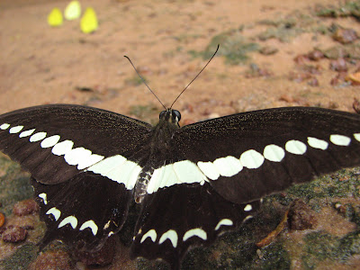
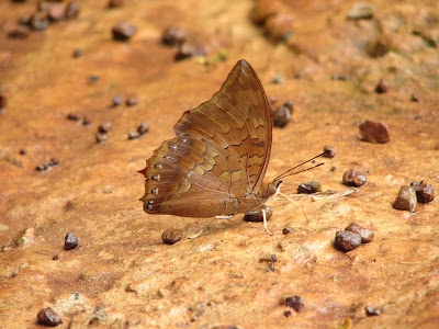
Not far from the signs I park my car beside the road and now we found amazine things that never seen before, a lot of butterfly come gather together to eat the orange-clay of the official name is salt lick, this is not wide area just 2x4 meters with prohibited to walk inside.

A line of 10 butterfies.

Look closer

More closer, this one I take a photo with macro shot to see it more detail on it's wings.

A Leaf in front of me, this is another kind that look like a leaf what it catch on the tree to hide the enemies.

Very closer I take this macro shot before it fly away from me.

Another one kind that look like a leaf.

This car bring us here I would say Thank you. :)
There are more images in take for butterfly in this our trip, but I don't know who would like to see more in this post maybe I will come to post again you request (Maybe a national geo graphic blog....just funny)
Please follow my next post.

Saturday, July 21, 2007

Pangsida National Park Trip (3.Visit Waterfall)

The rain is stoped but our funny is starting. We are walking into the lower level of the waterfall by the a wet and slippery condition way.

And now we just arrived to the one of beautiful waterfall.


Another view please be relax we have to respiration deeply for a fresh air which we never have in the town area.

The Sun shining into the falling water over us.

We found the pretty butterfly but we don't know how to call it's name, I's quite hard take this image closely.

As asking from the authority officer, she told us there are some places that are sources and easier to meet the covey of butterflies, please follow us.

Pangsida National Park Trip (2.Let See)

After got the hotel reservation for our tonight, we are not hesitate to go quickly to Pangsida Nation Park, the first sub destrination is Pangsida Waterfall using a highway no. 33 in Srakraw province and then turn right to a smaller highway 3462, click here to find the below location by google map.


I'm a car on 3462 by following the sign it was very easily my car ran on the street smoothly , andn then we spend some moment to have lunch beside our way.

I'm really don't want to believe, after finish our lunch break and drive forward for some few kilometers the rain is falling at the front of National Park gate, but that was not our problem.


Now we passed from the gate by paid for 2 personal fee tickets 20 baht each (left side) and a vehicle fee ticket 30 baht, so we just spend (20 x 2)+30 = 70 baht, it is very cheap to support the national park organization (Pangsida is just one inside all several national parks that they take care and support).

Is it monster? We are here arrived at the Pangsida waterfall by 3-5 minutes drive slowly on the heavy rain falling and stop my car at parking area, just take a look on my right hand side by without leave from a car. I saw a huge 1-2 meters butterfly on the tree. The rain is still falling and we're just to wait and wait and do nothing,..... until about next 2 hours the rain has stop and we are ready to go outside now.

Previous Trip page1 Visit Waterfall

Thursday, July 19, 2007

Pangsida National Park Trip (1.Introduce)

Pangsida National Park Trip
Pangsida Nation Park is about 844 km2 (Square kilometers) of area covered 2 provinces Prachinburi (Muang, Tapraya and WattanaNakornDistrict) and Srakrew (Nadee District)
Topography of Pangsida Nation Park are combine the tropical rain forest, steep moutains, waterfalls. There are a lot of animals such bull, elephant, red bull, tiger, deer, barking deer, bear, warthog, and hornbill.


Image from Pangsida Waterfall
Let go, My trip is began on 23 Jun 2007 time 8.10AM start from Bangkok (KrungThep) Minburi Destrict Ramintra road (Highway no. 304) my car is drived on the red highway 304 Suwinthawong , fortunately and I would say thanks for google they give a very useful tool google map for Thailand, if you need to follow me click here to find the below screen.

It was a very good day for our trip with my special person :) with a good street surface I'm still on highway no. 304 , if you still follow me drag you mouse on your right hand side you will found a junction, up to now we are take some few minues to verify where we are and then still drive on 304, if you are missing click here.


It quite long for 304, we passed some few junctions, you have to follow me on the red line, but in fact I drived in the wrong way to 319 , fortunately not far from here to found U-turn and get back to 304 again click here to go with us.

Just go straight on the highway 3097 is a smaller highway connect to the 359 up to now we found a sign to go to Srakraw province.

First of all congratulation we are at Srakraw province click here to get our first destrination.

Pangsida Nation Park area is 26 km. distance from Srakraw city area we arrived here on about 10:30 AM let look on meter the usage distance is about 190 km from our start point. so now I'm looking for hotel for reservation for tonight if you not require for the rest place inside the nation park area. There are several vacant hotel for you for the cheaper cost compare with the major city in Thailand, due to Srakraw province is the one of small coverage area and small city area and now we got one the hotel's name is Kawee hotel and it's cost us 400 baht/night, we are already checked for the most things inside our reserved room and everything fine.

Wednesday, July 18, 2007

What is Thailand?


What is Thailand?
Thailand is a country in south east asia closed to Laos and Cambodia in east, closed to Gulf of Thailand and Malaysia in south, Andaman Sea and Myanmar in west.
The capital city is Bangkok.Thailand is the world's 49th-largest country at 514,000 Km2 (square kilometers) divided into 76 provinces, which are gathered into 5 groups of provinces by location. There are also 2 special governed districts: the capital Bangkok (Krung Thep Maha Nakhon) and Pattaya.
The 76 provinces are as following:

Central:
Ang Thong
Bangkok (Krung Thep Maha Nakhon)
Chai Nat
Kanchanaburi
Lop Buri
Nakhon Nayok
Nakhon Pathom
Nonthaburi
Pathum Thani
Phetchaburi
Phra Nakhon Si Ayutthaya
Prachuap Khiri Khan
Ratchaburi
Samut Prakan
Samut Sakhon
Samut Songkhram
Saraburi
Sing Buri
Suphan Buri
Eastern
Chachoengsao
Chanthaburi
Chonburi
Prachinburi
Rayong
Sa Kaeo
Trat
Northern
Chiang Mai
Chiang Rai
Kamphaeng Phet
Lampang
Lamphun
Mae Hong Son
Nakhon Sawan
Nan
Phayao
Phetchabun
Phichit
Phitsanulok
Phrae
Sukhothai
Tak
Uthai Thani
Uttaradit
North Eastern
Amnat Charoen
Buri Ram
Chaiyaphum
Kalasin
Khon Kaen
Loei
Maha Sarakham
Mukdahan
Nakhon Phanom
Nakhon Ratchasima
Nong Bua Lamphu
Nong Khai
Roi Et
Sakon Nakhon
Si Sa Ket
Surin
Ubon Ratchathani
Udon Thani
Yasothon
Southern
Chumphon
Krabi
Nakhon Si Thammarat
Narathiwat
Pattani
Phang Nga
Phatthalung
Phuket
Ranong
Satun
Songkhla
Surat Thani
Trang
Yala

Tuesday, July 17, 2007

Hello Messages

Hello my visitors,
I'm grade to introduce my blog here with combine posts from my plenty place travelling experiences in Thailand (or called "Mueng Thai or Prated Thai"), you will see where I gone and what I seen and also how to going from starting (mostly Bangkok or called Krungthep) to our destinations, if you planning to have an opportunity to willing visit Thailand you may following as my content posting for the routing, street number, distance and map if you going by drive a car, or more details if you going by public transportation such bus number, usage time and so on other details.
Besides, I will share all of you for the most famous places of the travellers must to visit first inside Thailand this help you stop searching and stop asking yourself "where will I go","where can I go first","where I go to sleep, dinner, shopping","how can I..." or whatever.
Smith.